AR Navigation Maps Launched by Google for Android and iPhones
AR Navigation Maps

AR Navigation Maps Launched by Google: Image Source
Google frequently updates its browsing app with fresh features while testing using beta versions, and Google Maps improved as a consequence. But Google also has some features in the app that may not necessarily require a house in a navigation app. It is because Google wishes you to use Google Maps for almost all your travel needs. And that involves benefiting from what is likely the coolest Google Maps function that has been released on both Android and iPhone.
Google clarified in a blog article about Google Maps’ fresh function that Google Maps “will simplify your journey every step after you’ve reached a new town to live.” Google Maps will now incorporate all your travel information, including travel flights and hotel bookings, which are all put inside the hamburger in a fresh reservation menu element. It also operates in weak internet signals, no matter if you have an effective Internet link or not.
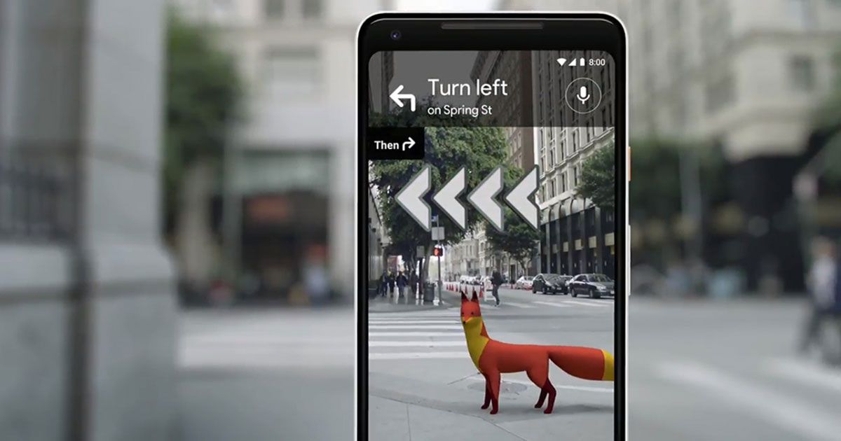
This year earlier, Google introduced a beta version with “Live View”, an Augmented Reality function. It enables consumers to use Google Maps and their Smartphone camera to see in real-time Augmented Reality overlays that show how far they can go and where to go next to each other. But Live View had only been accessible on Google Pixel phones— so far. Google announced today that Live View is now accessible on iPhones and a broader range of Android phones. Any Android device supporting ARCore or ARKit iPhones can use Live View in the Google Maps app.
What is really good with Live View is that it shows the path to follow by showing overlays of huge arrows and direction on your display. It makes it much easier to navigate the unknown region the first time you are there.
The Live View extension is just one aspect of the Google upgrades announced today for its Maps brand. Additional features include a one-stop “Reservations” menu, where you will be able to view all your stored reservations and hotel reservations, and a fresh schedule that will record and save all locations on your trip.
What is AR Function?
The AR navigation function overlays walking instructions across real-world roads. The map would indicate where we head and when we switch left or right or strike directly with a smartphone camera. The AR map relies on Google Street View information so that it does not operate on highways or not on the un-updated Street View database.
How to use AR Function?
You should open Google Maps and select a target. There is a fresh alternative called’ Start AR’ right next to the earlier ‘Start’ button. The display is divided into two components: the camera feed at top and the map perspective at the bottom. Then the app will prompt the recipient, and the app will detect the place just after a few seconds and provide directions.
When the place is verified there are two big blue buttons on the display that show the path the individual should take. This is one of the main advantages of using AR in maps because it overcomes the limitation of ordinary Google Maps-people gets often confused by directions.
The AR mode turns off when the device is reduced, and the ordinary navigation resumes. When the phone is lifted in hand again, AR mode is turned on again. Another significant feature in AR mode is that it prevents individuals from passing the roads while looking at the telephone. The app detects an individual shifting during AR mode. If you neglect the warning sign and continue, after a few seconds AR mode will become empty and demand that you reduce the device.
Background of Google AR Function in Map
The AR function for Google Maps was first announced in 2018 and was tested in private in February. Pixel consumers were willing to appreciate it by 2019. After months of experimentation, the function lastly has a title, Live View, and Android and iPhone customers will be free to use it with apps that promote ARKit and ARCore.
AR Live View
Live View uses what Google calls “Visual Positioning System” that operates by mixing GPS, camera footage and visual information to determine where a person lies and where he or she wants to go, as opposed to fundamental GPS.
Using Live View only needs the customers to direct the camera to their environment, and the AR technique helps the customer see which way to move in the correct direction with blinked arrows.
People who have a compliant phone and want to test the function just have to enter their location, tap on Walking Instructions and choose Live View. It is currently only accessible for navigation on foot, and it is not clear whether Google will finally adopt it for vehicle navigation.
Google Maps
Google Maps is now a stronger travel partner, besides Live View. The software also allows customers to view their hotel and plane bookings merely by taping the “Your location” and then the “Reservation” button to view a list of upcoming tours.
In addition, the “Your Match” function allows visitors to discover local restaurants, their must-test meals, book a reservation and even see how long they wait.
“These new tools simplify every phase of your journey after you have arranged your journey from going around a new town until every time you go back,” suggests Rachel Inman, UX Designer for Google Maps.
Read Next: Biometric Data of More Than a Million Users is Exposed Due to Huge Security Bugs


