This animation of NOAA’s GOES East and West satellite imagery from Oct. 1 at 3:30 a.m. EDT (0730 UTC) to Oct 8 at 8 a.m. EDT (1200 UTC) shows Hurricane …
Severe Tropical Cyclone Marcia made landfall along the central Queensland coast on Feb. 20, near the community of Rockhampton. The storm made landfall as a fearsome Category 5 cyclone but …
Combining various views from Nasa’s GOES 16 satellite we get a good view of Hurricane Harvey as it builts up and heads towards the Texas coast. The hurricane makes landfall …
This animation of NOAA’s GOES East satellite imagery from Sept. 17 at 7:15 a.m. EDT (1115 UTC) to Sept. 20 ending at 7:45 a.m. EDT (1145 UTC) shows Hurricane Jose …
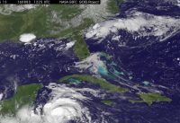
This animation for NOAA’s GOES-East satellite imagery shows the movement and strengthening of Earl from August 2 to August 4 through the Caribbean Sea to landfall in Belize. Credit: NASA/NOAA …
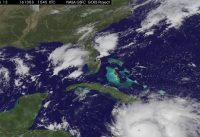
This animation of NOAA’s GOES-East satellite imagery from Oct. 2 to Oct. 4, 2016, shows Hurricane Matthew moving through the Caribbean Sea and making landfall on Oct. 4 over western …
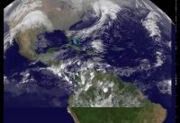
This animation of NOAA’s GOES-East satellite imagery from Nov. 22 to Nov. 25 shows Hurricane Otto moving through the southwestern Caribbean Sea and making landfall in southern Nicaragua on Nov. …