more at
Public domain film from NASA, slightly cropped to remove uneven edges, with the aspect ratio corrected, and mild video noise reduction applied.
The soundtrack was also processed with volume normalization, noise reduction, clipping reduction, and/or equalization (the resulting sound, though not perfect, is far less noisy than the original).
Transcript of the narration:
LDCM Overview
The Landsat Data Continuity Mission (LDCM) is a collaboration between NASA and the U.S. Geological Survey that will continue the Landsat Program’s 40-year data record of monitoring Earth’s landscapes from space. LDCM will expand and improve on that record with observations that advance a wide range of Earth sciences and contribute to the management of agriculture, water and forest resources.
The Landsat Program is a series of Earth-observing satellite missions jointly managed by NASA and the U.S. Geological Survey. The first Landsat satellite launched in 1972 and the next satellite in the series, the Landsat Data Continuity Mission — LDCM, is scheduled to launch on February 11, 2013.
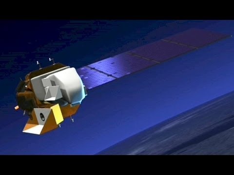
LDCM Spacecraft
Following launch, the LDCM satellite system will consist of two major segments: the observatory and the ground system. The observatory consists of the spacecraft bus and its payload of two Earth observing sensors, the Operational Land Imager (OLI) and the Thermal Infrared Sensor (TIRS). OLI and TIRS will collect the LDCM science data. The two sensors will coincidently collect multispectral digital images of the global land surface including coastal regions, polar ice, islands, and the continental areas. The spacecraft bus will store the OLI and TIRS data on an onboard solid-state recorder and then transmit the data to ground receiving stations.
The ground system will provide the capabilities necessary for planning and scheduling the operations of the LDCM observatory and the capabilities necessary to manage the science data following transmission from the spacecraft.
The LDCM spacecraft, built by Orbital Sciences Corporation, has a design life of 5 years, but carries sufficient fuel for 10 years of operations.
OLI
The Operational Land Imager (OLI), built by the Ball Aerospace & Technologies Corporation, will measure in the visible, near infrared, and short wave infrared portions of the spectrum. Its images will have 15-meter (49 ft.) panchromatic and 30-meter multi-spectral spatial resolutions along a 185 km (115 miles) wide swath, covering wide areas of the Earth’s landscape while providing sufficient resolution to distinguish features like urban centers, farms, forests and other land uses. The entire Earth will fall within view once every 16 days due to LDCM’s near-polar orbit.
OLI’s design is an advancement in Landsat sensor technology and uses an approach demonstrated by the Advanced Land Imager sensor flown on NASA’s experimental EO-1 satellite. Instruments on earlier Landsat satellites employed scan mirrors to sweep the instrument fields of view across the surface swath width and transmit light to a few detectors. The OLI will instead use long detector arrays, with over 7,000 detectors per spectral band, aligned across its focal plane to view across the swath. This “push-broom” design results in a more sensitive instrument providing improved land surface information with fewer moving parts. With an improved signal-to-noise ratio compared to past Landsat instruments, engineers expect this new OLI design to be more reliable and to provide improved performance.
TIRS
The Thermal Infrared Sensor (TIRS) will measure land surface temperature in two thermal bands with a new technology that applies quantum physics to detect heat.
TIRS was added to the satellite mission when it became clear that state water resource managers rely on the highly accurate measurements of Earth’s thermal energy obtained by LDCM’s predecessors, Landsat 5 and Landsat 7, to track how land and water are being used. With nearly 80 percent of the fresh water in the Western U.S. being used to irrigate crops, TIRS will become an invaluable tool for managing water consumption.
TIRS uses Quantum Well Infrared Photodetectors (QWIPs) to detect long wavelengths of light emitted by the Earth whose intensity depends on surface temperature…
